
The Most Beautiful Volcano in the World — and Why That’s the Least Interesting Thing About It
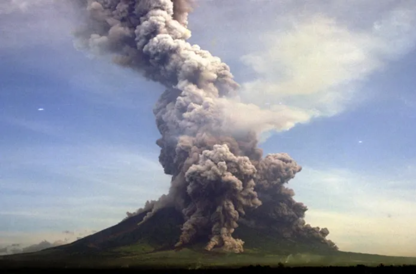
Mayon is famed for its near-perfect cone. But beneath that postcard silhouette lies 400 years of eruptive history, remarkable geology, and a story that makes every visit feel just a little more electric.

ELEVATION
2,462 meters above sea level

UPPER SLOPE ANGLE
35–40°, unusually steep

RECORDED ERUPTIONS
Mayon Volcano is one of the Philippines’ most active volcanoes, with more than 60 recorded eruptions over the past 500 years.

BASE DIAMETER
17 × 17.5 km at sea level
A cone so perfect, it barely looks real
There’s a moment, usually from a jeepney window or across a rice field on a clear morning, when you first see Mayon and your brain doesn’t believe it. The cone rises almost seamlessly out of the Gulf of Albay lowlands, its upper flanks rising at a near-impossible 35 to 40 degrees before tapering to a small crater just 200 metres across at the summit. Volcanologists from around the world cite it as the most symmetrically perfect stratovolcano on Earth. Even Fuji, Japan’s iconic sacred peak, doesn’t quite measure up.
What makes this symmetry possible? Mayon’s edifice is built from alternating layers of basaltic pyroclastic deposits and andesitic lava flows, material that stacks evenly in all directions with each eruption. The result is a volcano that looks almost sculpted, a near-cone rising 2,463 metres with a prominence of 2,447 metres, meaning it effectively begins at sea level. Its base spans 17 by 17.5 kilometres, giving it a conical volume of roughly 160 to 189 cubic kilometres.
Viaje tip: The clearest views of Mayon are typically in the early morning before clouds gather around the summit. The vantage from Cagsawa Ruins in Daraga, where the iconic bell tower frames the cone, is one of the most photographed sights in the entire Bicol region.
It sits on eight municipalities, and all of them feel it.
Mayon doesn’t belong to a single town. The volcano is geographically shared by eight municipalities arrayed in a clockwise ring from the north: Tabaco, Malilipot, Santo Domingo, Legazpi, Daraga, Camalig, Guinobatan, and Ligao. Most of these sit roughly 10 kilometres from the peak, close enough that on an eruption night, the glow is unmissable from every rooftop. Legazpi City, the regional centre, lies just to the south-southeast, practically at Mayon’s feet.
This also means that the volcano quietly shapes the rhythm of life across Albay. Farmers read the cloud formations. Locals know its alert levels. And travelers who take the time to understand it find that the experience of being in Albay is richer for it; the mountain isn’t just scenery, it’s context.
Four centuries of eruptions, a condensed history
1616: First recorded eruption. Dutch explorer Joris van Spilbergen documented the eruption in his circumnavigation log, the earliest Western record of Mayon in action.
1766: First extended account. A six-day eruption beginning July 20th. Months later, a typhoon remobilised the volcanic debris into deadly lahars, burying villages across the province.
1814: The great Plinian eruption -VEI 4. Mayon’s most devastating eruption. An estimated 1,200 lives were lost as pyroclastic flows and ash engulfed villages across Albay and Camarines. The ruins of Cagsawa Church, still standing today in Daraga, are the most visible scar of that day.
1897: Seven days of fire -VEI 4. A Vulcanian eruption that rained fire on Bacacay, Libon, and San Roque for an uninterrupted week, killing hundreds from lava bombs, lava flows, and pyroclastic flows.
1984: Monitoring saves 75,000 lives. PHIVOLCS recommended evacuation of the danger zone. All 75,000 residents were evacuated in time, with zero casualties, a landmark moment in Philippine disaster preparedness.
2006: Typhoon Durian lahars. Following an effusive eruption in July, Typhoon Durian’s rainfall remobilised volcanic material into lahars on November 30th, killing at least 1,266 people and burying parts of Legazpi City’s outer suburbs under mud.
2013: Sudden phreatic explosion. A summit explosion with no prior warning killed five climbers, a reminder that Mayon’s hazard is never entirely predictable from the surface.
The geology that makes Mayon extraordinary
Here’s where it gets genuinely fascinating. Mayon sits inside the Bicol Basin, a small sedimentary basin, meaning the volcano rises from water-rich, layered rock rather than solid igneous crust. This is the same geological setting as the Campanian region of Italy, home to Vesuvius. The water content in those sediments makes eruptions more explosive and provides a ready supply of material that can be transformed into evolved magmas over time. It also raises questions about the long-term load-bearing capacity of the ground beneath such a massive edifice.
The volcano also sits near the Philippine Trench, the convergent boundary where the Philippine Sea Plate subducts under the Philippine Mobile Belt. That subduction is ultimately what fuels Mayon’s magma supply, giving it what volcanologists describe as a prodigious and continuous influx of fresh juvenile magma. Mayon erupts frequently because the pipeline never fully closes.
One of the more striking geological findings: fractures have been identified on Mayon’s western and eastern flanks that align with the regional tectonic faults of the Bicol Basin. These are the same structural patterns seen in volcanoes that have experienced catastrophic flank collapses elsewhere in the world. PHIVOLCS monitors these closely.
The symmetry problem, beautiful and sobering
Mayon’s perfect cone creates a unique challenge for hazard management: precisely because it is so symmetrical, pyroclastic flows and lahars can travel down any of its flanks in any direction. There is no “safe side.” When PHIVOLCS designates danger zones, it must account for the possibility of flows heading toward any of the eight surrounding municipalities simultaneously. The mountain’s beauty, in this sense, is inseparable from its unpredictability.
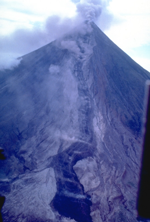
In March 1993, a stream of lava advanced down Mayon Volcano's eastern flank through the Bonga Valley, reaching approximately 4.5 kilometers by March 26. The flow partially filled the deep valley, which had been carved by powerful pyroclastic flows during the volcano's 1984 eruption, illustrating how each eruption continues to reshape Mayon's landscape.

Photo: Philippine Institute of Volcanology and Seismology (PHIVOLCS), 1993.
Lahars, volcanic mudflows triggered by rainfall on ash-covered slopes, are considered the most likely ongoing hazard. Torrential rain can remobilise volcanic material months or even years after an eruption. Mayon sits in a typhoon belt, with heavy annual rainfall that keeps this risk perennial rather than seasonal.
What the Cagsawa Ruins tell us
No visit to Albay is complete without Cagsawa, and most visitors come for the iconic photo: the old bell tower of the ruined Franciscan church, framed against Mayon’s perfect cone. But the ruins are more than a backdrop. They mark the site where, during the 1814 eruption, many people who sought shelter inside the church are believed to have perished when pyroclastic flows engulfed the area. The bell tower is all that remains above the volcanic deposits. Standing there, with the volcano rising behind you and the ruins before you, history feels inescapable, making the view far more profound than any photograph can capture.
The very ground beneath Cagsawa Ruins lies several metres above the original floor level of the church, raised by centuries of accumulated volcanic material from Mayon’s eruptions. You’re standing on the mountain’s history.
Visiting safely: what travelers should know
Mayon is an active volcano, and that activity is precisely what makes Albay so compelling. The good news: PHIVOLCS maintains one of the most sophisticated volcano monitoring operations in Southeast Asia, operating from an observatory atop Lignon Hill, itself a prehistoric cinder cone just north of Legazpi City. Alert levels are published in real time, and local authorities have decades of experience executing rapid, large-scale evacuations.
For travelers, the practical guidance is simple: check the current PHIVOLCS alert level before booking any activities near the volcano, follow local authority instructions without exception, and choose accredited tour operators for ATV trails, trekking, and adventure activities around the slopes. When Mayon is quiet, those experiences are extraordinary. The ATV trails through lahar fields and lava flows are unlike anything else in the Philippines.
Alert level to watch
0–5
0 = normal, 5 = critical
Danger zone (standard)
8 km
from the summit crater
Best viewing season
Dec–May
dry season, clearer skies
Why Mayon belongs on your Albay itinerary
Most travelers arrive in Albay expecting a beautiful volcano. They leave having understood something deeper, that living beside an active stratovolcano shapes a culture in ways that are visible in everything from the architecture of evacuation centres to the way locals talk about the mountain with a mixture of reverence and matter-of-fact familiarity. Mayon is not a backdrop. It is the reason Albay exists the way it does: fertile, dramatic, alive.
Book your Albay experience through Viaje and see Mayon the way it deserves to be seen, with full context, safe logistics, and the kind of local knowledge that turns a postcard view into a memory you’ll carry for years.